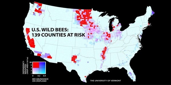
Though they’re tiny, bees play a big role in making our food. But these fuzzy fliers are in trouble—and a new map highlights just how precarious the pollinator’s situation has become in the United States. Recently presented at the American Association for the Advancement of Science (AAAS) annual meeting, the map highlights 139 counties across the country where wild bees are at risk. Many of these danger regions encompass major agricultural zones like California’s Central Valley and a wide swath of the Great Plains. “This study provides the first national picture of wild bees and their impacts on pollination," Taylor Ricketts, conservation ecologist at the University of Vermont and one of the study’s authors, says in a press release. Ricketts and his team created the maps by identifying 45 types of land cover from two federal databases. They then queried bee experts around the country about how well each land cover type provides wild bees with nesting and food resources. From this information, the researchers built a model that predicts the relative abundance of wild bees across the contiguous U.S., which they tested against bee collections and field observations. The researchers published their study last year in the journal Proceedings of the National Academy of Sciences.
Read more: http://www.smithsonianmag.com/smart-news/new-map-highlights-bee-populat…
Follow us: @SmithsonianMag on Twitter

- Login om te reageren
